Our planned 4000 nm 35 day trip turned into a 4800 nm 42 day voyage.
We had to take a more southern route to avoid some strong storms
In the first 2 weeks we had a lot of sunny days and was able to get a
noon sextant site to find out where we were!
We also had a lot of beautiful sunsets. We didn't realize that soon we
wouldn't see the sun for several weeks
Enroute I noticed my radio antenae had broke so I had to go up
the mast to lash it down. Not a fun job when the mast is swinging in
the swells in the middle of the North Pacific Ocean
Noelle kept us supplied with fresh bread
She also helped steer through the last of the 4 gales we went through
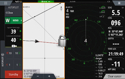
The reality is that most of the time we used autopilot and looked out the windows once it got cold and rainy. The chart plotter has a spit screen mode with autopilot control on the left
chart left center to watch for ship AIS signals
radar zoomed in right of center to pick up small objects
A lot of the time it was too foggy or dark to see anything visually so radar is great.
Below is a sailing video
Finally just before 0100 local time on the 19th of June we dropped anchor
outside a marina on Kodiak Island. We plan to go into the marina when it opens in the am


Comments
Post a Comment